Written by: Madam Taqiyya
Four students from Geodesy and Geomatics Engineering, Bandung Institute of Technology developed NAWH S-100 project as their capstone project (final project). They are Mochamad Hasnan, Raden Almafayra Z, Najiyah Nurul Faizah, and Wanda Putri. NAWH S-100 is the first IHO S-100 standardized data service system developed in Indonesia by Indonesians.
The Needs of Standard Hydrographic Data
Nowadays, shipping industry grows rapidly and increases in number and size of ship as shipping industry is responsible for 90% of world trade. Consequently, ship accident becomes a concern for the damage it caused including loss of life, economic damage, and environmental pollution. The investigation on the ship accident shows that more than 30% of the accident is caused by bad weather (Zhang & Li, 2017). In 2020, an accident happened around the northern part of the South China Sea. A fishing vessel, Yong Yu Sing No.18 was caught in a storm and off-course. The vessel is found in Pacific Ocean, but the 10 crews had never been found (Taiwan Transportation Safety Board, 2020). Therefore, the standardized and globally accessible hydrographic data is highly demanded, especially in the needs of safe navigation and management of the maritime environment. One of the data that is very important in maritime navigation and safety sector is meteorological data. Moreover, the data provider should consider standardized and accessible hydrographic data (Kastrisios, 2022).
What is S-100?
S-57 has been the standard format data for hydrographic digital data exchange, including Electronic Navigation Chart (ENC) since 1992. Higher connectivity opens opportunity for global data exchange as the number of hydrographic data source is increasing in number (UK Hydrographic Office, 2023). Meanwhile, S-57 has some limitations amidst rapid technology development, such as format complexity, limited attribute information, limited representative data, and complicated updated processes. International Hydrographic Organization (IHO) overcomes those limitations through IHO S-100 (UK Hydrographic Office, 2023).
IHO S-100 is a framework for the development of digital product and services for hydrographic, maritime, and GIS communities. As a successor to IHO S-57, IHO S-100 must support the future needs e.g. bathymetry grid or other information that changes over time. Therefore, S-100 is making machine-readable catalog mechanism, and stipulating that the standard S-100 data must be globally consistent and encode in a specific format (Powell, 2021).
S-100 Data Availability in Indonesia
Most product of standardized IHO S-100 data service comes from United Kingdom (UK) and United State (US), very well-known country in this industry. The UK is the leading nation in S-100 standardized data development. Indonesia as the maritime country essentially has great interest in developing its maritime affair. On the other hand, the development of Indonesia maritime data service, especially with the IHO S-100 standard has not developed as much as the UK or the US. Currently, there is no data service providers which produce data with IHO S-100 standard except NAWH S-100.

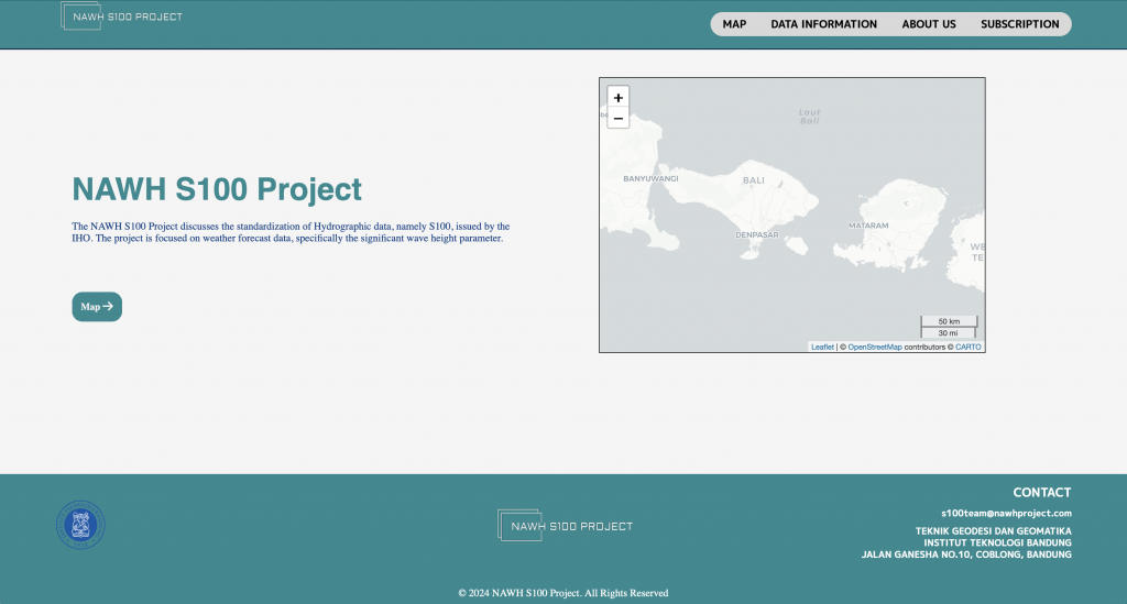
NAWH S-100 user interface.
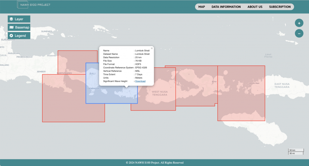
NAWH S-100 aims to provide weather data over Indonesia, particularly significant wave height data adapted to IHO S-100 specifications and standards that can be easily accessed by users. For now, NAWH S-100 Project covers Lombok Strait area. To meet the S-100 standard, significant wave height is encoded in IHO S-100 format, updated daily, and easily accessed via a webpage. NAWH S-100 is expected to be the initial step on the implementation and development of IHO S-100 standard that will inspire related institutions in Indonesia.
Check NAWH S-100 here!

NAWH S-100 displayed area and metadata.
This article is summarized from Capstone Project Report by Mochamad Hasnan, Raden Almafayra Z, Najiyah Nurul Faizah, and Wanda Putri. Title: “PENGADAAN DATA CUACA BERSTANDAR S-100 DI SELAT LOMBOK”
References:
Kastrisios, C. (2022). The Geographic Information Science & Technology Body of Knowledge. Hydrographyc Geospatial Data Standards, 1-2. https://doi.org/10.22224/gistbok/2022.2.5
Powell, J. (2021). S-100: A Brief Introduction. Retrieved from iho-machc.org: https://www.iho-machc.org/documents/cbc/Webinar2021/MACHC_S100%20Presentation.pdf
Taiwan Transportation Safety Board. (2020, 12 26). Yong Yusing No.18 Fishing Vessel Major Marine Occurrence. Retrieved from Taiwan Transportation Safety Board: https://www.ttsb.gov.tw/english/18609/28176/36749/post
UK Hydrographic Office. (2023, May 24). S-57 to S-101: Explaining the IHO standards for ECDIS. Retrieved from Retrieved from Admiralty.co.uk: https://www.admiralty.co.uk/news/s-57-s-101-explaining-iho-standards-ecdis
Zhang, Z., & Li, X. M. (2017). Global ship accidents and ocean swell-related sea states. Natural Hazard and Earth Science System, 2041-2051.
