Written by: Rasya Intishar
BANDUNG – A research team led by Iyan E. Mulia from the Hydrography Research Group, Faculty of Earth Sciences and Technology (FITB), Institut Teknologi Bandung (ITB), has developed an artificial intelligence (AI) model that rapidly forecasts tsunami inundation while also quantifying its uncertainty. The study, titled “AI-based ensemble tsunami inundation forecasting,” was published in Coastal Engineering, volume 212 (2026), and has been available online since July 13, 2026.
Tsunami inundation forecasts should ideally be not only fast and accurate but also account for uncertainty. For near-field tsunamis, the largest source of uncertainty is the earthquake’s slip distribution, which cannot be determined with certainty in the moments after an earthquake. At the same time, operational inundation forecasting systems remain limited in many countries, particularly those with restricted computing resources.
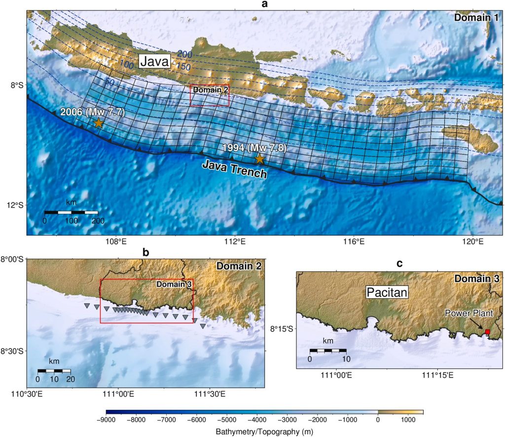
The study focuses on Pacitan Regency, East Java, which directly faces the Java Trench subduction zone. The region has been affected by the 1994 Banyuwangi tsunami (Mw 7.8) and the 2006 Pangandaran tsunami (Mw 7.7). With around 600,000 residents, more than one million tourists each year, and a coastal power plant that is part of Indonesia’s national strategic projects, Pacitan is one of the country’s priority areas for tsunami mitigation.
The AI model was trained on 630 hypothetical tsunami scenarios ranging from Mw 7.6 to Mw 9.2. Built on a one-dimensional convolutional neural network (1D CNN), the model learns the relationship between tsunami waveforms at 20 virtual observation points along the 50-metre depth contour and the resulting inundation maps on land.
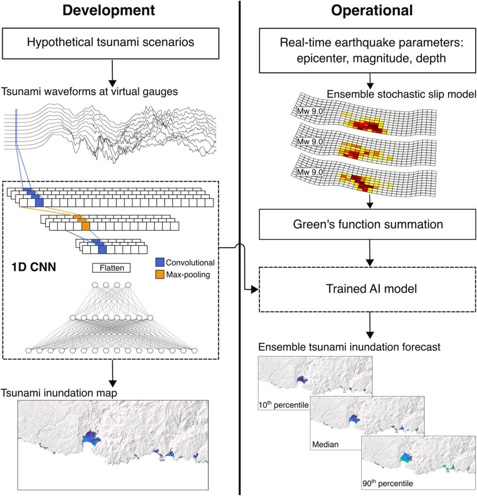
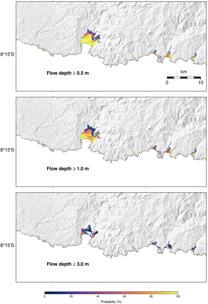
When an earthquake occurs, the system requires only the epicentre, magnitude, and depth provided by earthquake monitoring agencies. From this information, it generates 100 possible slip distributions, computes their tsunami waveforms using a Green’s function technique, and feeds them into the AI model to produce 100 inundation forecasts. The results can be presented as a median forecast, a range from the 10th to the 90th percentile, and maps showing the probability of flow depths exceeding 0.5 m, 1 m, and 3 m.
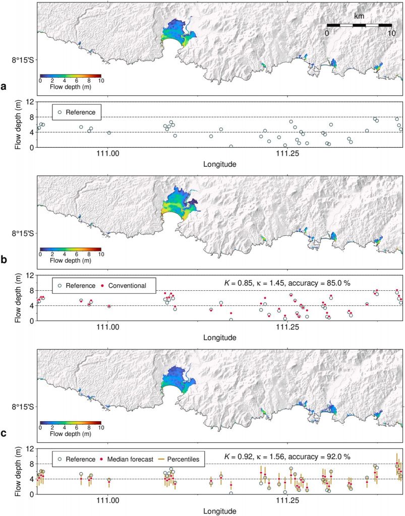
In a test using a hypothetical Mw 8.8 earthquake off the south coast of Java, the model’s median forecast achieved 92% accuracy, outperforming the conventional uniform-slip method, which reached 85%. All 100 forecasts were completed in 10–12 seconds on a single NVIDIA GeForce RTX 4060 GPU, enabling real-time probabilistic forecasting with relatively affordable hardware.
The researchers also note several limitations. The model is designed specifically for tsunamis generated by megathrust earthquakes and does not yet account for “tsunami earthquakes,” which produce larger tsunamis than their magnitude would suggest, such as the 2006 Pangandaran event. Future work will explore the use of GNSS data and optimised tsunami observation networks, as well as integration into a broader probabilistic tsunami forecasting system.
The study involved researchers from ITB, the RIKEN Center for Advanced Intelligence Project (Japan), Earth Sciences New Zealand, and Indonesia’s National Disaster Management Authority (BNPB), and was funded through the PPMI FITB 2026 Programme. The approach is expected to support better-informed evacuation decisions, especially in regions with limited observation networks and computing infrastructure.