
Written by: Miga Magenika Julian
Flooding in Jakarta isn’t just an inconvenience—it’s a recurring disaster. The capital of Indonesia, home to more than 11 million people, has faced devastating floods over the years, with the 2007 flood being one of the worst in recent history. That year, nearly 60% of the city was submerged, 80 people lost their lives, and economic losses were estimated at over 700 million US dollars. But what if we could have seen it coming—clearly and early enough to take action?
That’s exactly what we set out to explore by looking upstream, toward Katulampa in the upper Ciliwung basin, and using hydrological modeling. The tool we used is called J2000, a process-based model that helps simulate how water behaves across landscapes. This model doesn’t just predict runoff—it maps how water flows across soil, through groundwater, and into rivers. By understanding these dynamics, the model can anticipate flooding before it happens downstream in Jakarta.
Why Focus on Katulampa?
Katulampa, a hilly area in Bogor, plays a critical role in Jakarta’s water system (Figure 1). Rain that falls there can become runoff that eventually rushes into the capital. The Katulampa floodgate has long served as a frontline monitor. But until now, its data hadn’t been used in such a detailed simulation of a major historical flood.
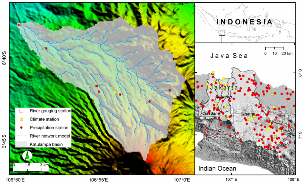
Figure 1. Study area: Katulampa in the hilly part of the Ciliwung basin
We reconstructed the 2007 flood and plugged it into the J2000 model. We examined not just rainfall input, but also topography, land use, soil types, and daily climate data such as temperature and sunshine. The result? A simulation that closely matched reality.
What Did We Find?
In February 2007, Katulampa received a massive 122 mm of rainfall in a single day—nine times more than the average. This extreme downpour overwhelmed the land, particularly areas covered by buildings and roads that prevent water from soaking into the ground. According to the model, 89% of the resulting runoff came from overland flow, or surface water unable to infiltrate the soil. This highlights how urbanization and impermeable surfaces significantly worsen flood risks.
The J2000 model successfully reproduced this event (Figure 2), showing good accuracy based on statistical measures. It even captured the timing and magnitude of peak runoff, confirming that this type of modeling can support early warning systems.
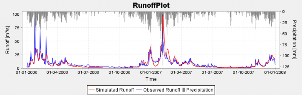
Figure 2. Observed runoff vs. simulated runoff in the Katulampa gauging station
A Glimpse into Jakarta’s Future
What makes this research particularly valuable is its potential to guide future decisions. By showing how sensitive runoff is to changes in rainfall and temperature, the model emphasizes the growing impact of climate change. A 10% increase in precipitation, for instance, would cause a 7.3% increase in runoff—meaning heavier floods, faster.
Beyond weather, land-use decisions are also key. Jakarta’s rapid urbanization has led to shrinking green spaces and expanding concrete jungles. This makes it harder for the ground to absorb rainwater and easier for floods to happen. The model shows that even small changes in land use or rainfall can lead to big impacts downstream.
What Can Be Done?
The study suggests several practical steps. First, upstream monitoring at places like Katulampa should be enhanced and integrated into Jakarta’s flood warning systems. Second, hydrological models like J2000 should be used to support urban planning—especially to design better drainage, protect green areas, and avoid building in flood-prone zones.
Third, the approach should be expanded to other river basins that feed into Jakarta, such as the Angke and Sunter basins, to build a city-wide understanding of flood risks.
An Initial Model for Resilience
The takeaway is clear: Jakarta can’t stop the rain, but it can manage its consequences. Hydrological modeling provides a scientific lens through which we can understand floods—not just as random disasters, but as predictable events shaped by land, water, and climate.
With tools like J2000 and the insights from Katulampa, we have the power to forecast floods more accurately, protect vulnerable communities, and design a more resilient Jakarta for the future.
Further readings: https://iopscience.iop.org/article/10.1088/1755-1315/1496/1/012010
Featured Image:
Flood illustration by Vectorfair J. Accessed via Canva Pro.